Devlin Hosguard
Admin


Posts : 536
Join date : 2012-01-06
Location : Alfred, New York
SP/MP/HP
HP:
    (2800/2800) (2800/2800)
SP:
(1046/2270)
MP:
(2400/3020)
 |  Subject: Geography of Runa Sat Jan 07, 2012 9:32 pm Subject: Geography of Runa Sat Jan 07, 2012 9:32 pm | |
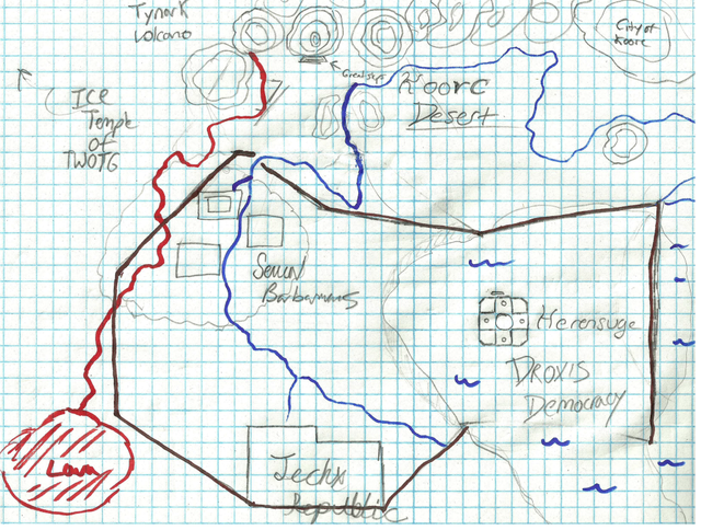
| The three colonies only take up the top third of the planet. The other two thirds is split between glaciers, grasslands, and a few seas. Otherwise the geography for the region where the colonies exist is as follows (Image and Clarification available upon request):
-Serial Barbarians live in the Forest of Selgeran which is a forest that 195 square miles in the northwestern corner of the map. The village of Daquan is on the edge of the forest closest to the cavern entrance to Senka (a mere 150 miles away (Across Grassland and Glaciers). Anselme was 15 miles north through the forest from Daquan. The village of Asger is 60 miles east from Anselme on the edge of the forest 120 miles from Herensuge.
-Droxis Democracy is the eastern most civilization. The city of Herensuge is built in the middle of the Ocean of Settozai. The island is in the approximate shape of an upside down P (with no gap in the letter) taking up 21, 525 square miles of ocean.
-Jechx Republic the southernmost civilization is seated underneath an extensiver expansion of glaciers. The entrance of Senka is the western most city entrance; with it's cavern entrance 150 miles southeast from Daquan. Eighty-five miles southeast from Senka's cavern entrance is the entrance to the captial of Molimo. Eighty-Five miles northeast from Molimo is the cavern entrance of Ohanzee.
-Between the civilizations is a a "Y" shaped expanse of grasslands that ends at the Ocean of Settozai and the beginning of the glaciers before the Jechx Republic. | |
|
Devlin Hosguard
Admin
Posts : 536
Join date : 2012-01-06
Location : Alfred, New York
SP/MP/HP
HP:
(2800/2800)
SP:
(1046/2270)
MP:
(2400/3020)
| | Subject: Update: Map Level 1 (DO NOT STEAL!) Fri May 18, 2012 5:12 pm | |
| | |
|